Log in
All resources
Create a design
947 Free Artworks of Maps Of The Netherlands
copper engraving print
joan blaeu
british library
atlas maior, vol 4 (netherlands) - joan blaeu, 1667 - bl 114.h(star).4
bibliothèque nationale de france
1667 maps
map of maastricht by willem and johannes blaeu (1649)
maps of the course of the rhine by guillaume sanson
baroque
maps by matthäus merian
map of maastricht by willem and johannes blaeu (1649)
first medieval city wall of maastricht
maps by pieter van der keere
old maps of gelderland
engravings by romeyn de hooghe
proveniershof, haarlem
david rumsey historical map collection
old maps of the holy roman empire
1750s maps of the netherlands
hendrik de leth
maps from university of amsterdam special collections
atlas der neederlanden
maps of rotterdam by braun & hogenberg
maps of gouda by braun & hogenberg
atlas maior, vol 4 (netherlands) - joan blaeu, 1667 - bl 114.h(star).4
1667 maps
atlas maior, vol 4 (netherlands) - joan blaeu, 1667 - bl 114.h(star).4
1667 maps
atlas maior, vol 4 (netherlands) - joan blaeu, 1667 - bl 114.h(star).4
1667 maps
atlas maior, vol 4 (netherlands) - joan blaeu, 1667 - bl 114.h(star).4
1667 maps
atlas maior, vol 4 (netherlands) - joan blaeu, 1667 - bl 114.h(star).4
1667 maps
atlas maior, vol 4 (netherlands) - joan blaeu, 1667 - bl 114.h(star).4
1667 maps
atlas maior, vol 4 (netherlands) - joan blaeu, 1667 - bl 114.h(star).4
1667 maps
map of maastricht by willem and johannes blaeu (1649)
meuse river in maastricht
atlas maior, vol 4 (netherlands) - joan blaeu, 1667 - bl 114.h(star).4
1667 maps
atlas maior, vol 4 (netherlands) - joan blaeu, 1667 - bl 114.h(star).4
1667 maps
atlas maior, vol 4 (netherlands) - joan blaeu, 1667 - bl 114.h(star).4
1667 maps
atlas maior, vol 4 (netherlands) - joan blaeu, 1667 - bl 114.h(star).4
1667 maps
atlas maior, vol 4 (netherlands) - joan blaeu, 1667 - bl 114.h(star).4
1667 maps
atlas maior, vol 4 (netherlands) - joan blaeu, 1667 - bl 114.h(star).4
1667 maps
1620s maps of the netherlands
maps by pieter van der keere
maps of the course of the rhine by guillaume sanson
bibliothèque nationale de france
maps of the course of the rhine by guillaume sanson
bibliothèque nationale de france
maps in the british museum
taddeo crivelli
atlas ou representation du monde universel t. 1 (1633)
1630s maps of the netherlands
map of maastricht by willem and johannes blaeu (1649)
jekerkwartier (maastricht)
early netherlandish painting,northern renaissance
the garden of earthly delights, closed
atlas maior, vol 4 (netherlands) - joan blaeu, 1667 - bl 114.h(star).4
1667 maps
atlas maior, vol 4 (netherlands) - joan blaeu, 1667 - bl 114.h(star).4
1667 maps
atlas maior, vol 4 (netherlands) - joan blaeu, 1667 - bl 114.h(star).4
1667 maps
atlas maior, vol 4 (netherlands) - joan blaeu, 1667 - bl 114.h(star).4
1667 maps
map of maastricht by willem and johannes blaeu (1649)
history of wyck (maastricht)
gemeente atlas van nederland - gelderland
maps of ede, netherlands
maps by alexis-hubert jaillot
old maps of duchy of cleves
maps of goa by linschoten
maps
historical royal coats of arms of the netherlands
maps by willem and johannes blaeu
stedelijke internationale tentoonstelling van kunstwerken van levende meesters
expressionism,de stijl
maps by isaak tirion
old maps of haarlem
atlas maior, vol 4 (netherlands) - joan blaeu, 1667 - bl 114.h(star).4
copper engraving print
atlas maior, vol 4 (netherlands) - joan blaeu, 1667 - bl 114.h(star).4
copper engraving print
atlas maior, vol 4 (netherlands) - joan blaeu, 1667 - bl 114.h(star).4
copper engraving print
paraguay, o prov. de rio de la plata cum regionibus adiacentibus tucuman et sta cruz de la sierra - (blaeu) - btv1b8596658x
1640s maps of south america
atlas maior, vol 4 (netherlands) - joan blaeu, 1667 - bl 114.h(star).4
copper engraving print
atlas maior, vol 4 (netherlands) - joan blaeu, 1667 - bl 114.h(star).4
copper engraving print
atlas maior, vol 4 (netherlands) - joan blaeu, 1667 - bl 114.h(star).4
copper engraving print
atlas maior, vol 4 (netherlands) - joan blaeu, 1667 - bl 114.h(star).4
1667 maps
atlas maior, vol 4 (netherlands) - joan blaeu, 1667 - bl 114.h(star).4
1667 maps
1640s maps of the netherlands
maps by nicolaes visscher i
maps of breda, netherlands
piet schipperus
prints by abraham allard in the rijksmuseum amsterdam
maps in the rijksmuseum amsterdam
pieter verbiest (ii)
maps from gallica
maps of the course of the rhine by guillaume sanson
robert cordier (engraver)
old maps of amsterdam
hendrik de leth
maps by alexis-hubert jaillot
old maps of duchy of cleves
pieter verbiest (ii)
maps from gallica
cartography
maps
history of the low countries
netherlands in the 1630s
map of maastricht by willem and johannes blaeu (1649)
first medieval city wall of maastricht
map of maastricht by willem and johannes blaeu (1649)
grote gracht (maastricht)
broadsheet prints from koninklijke bibliotheek - maps
broadsheet prints from koninklijke bibliotheek
media from regionaal archief alkmaar
1670s maps of the netherlands
old maps of enkhuizen
baroque
maps of leeuwarden by braun & hogenberg
maps of franeker by braun & hogenberg
old maps of zutphen
baroque
maps of deventer by braun & hogenberg
bibliothèque nationale de france
map collection of leibniz-institut für länderkunde
1810s maps of the netherlands
atlas van der hagen (volume 2)
atlas van der hagen
atlas maior, vol 4 (netherlands) - joan blaeu, 1667 - bl 114.h(star).4
1667 maps
maps of the hague by braun & hogenberg
the hague in the 1700s
atlas maior, vol 4 (netherlands) - joan blaeu, 1667 - bl 114.h(star).4
copper engraving print
atlas maior, vol 4 (netherlands) - joan blaeu, 1667 - bl 114.h(star).4
copper engraving print
atlas maior, vol 4 (netherlands) - joan blaeu, 1667 - bl 114.h(star).4
copper engraving print
atlas maior, vol 4 (netherlands) - joan blaeu, 1667 - bl 114.h(star).4
copper engraving print
prints of cartouches in the rijksmuseum amsterdam
maps in the rijksmuseum amsterdam
map of maastricht by willem and johannes blaeu (1649)
kleine gracht (maastricht)
maps by willem and johannes blaeu
1640s maps of belgium
maps of the course of the rhine by guillaume sanson
maps by nicolas sanson
maps of amersfoort by braun & hogenberg
atlas de wit 1698
atlas maior, vol 4 (netherlands) - joan blaeu, 1667 - bl 114.h(star).4
1667 maps
maps in the library of congress
1849 maps
maps by matthäus merian
baroque
old maps of groningen (city)
baroque
18th-century maps of the iberian peninsula
maps in the rijksmuseum amsterdam
old maps of middelburg, zeeland
maps by nicolaes visscher i
maps of enkhuizen by braun & hogenberg
bibliothèque nationale de france
maps by matthäus merian
baroque
maps of dordrecht by braun & hogenberg
bibliothèque nationale de france
atlas maior, vol 4 (netherlands) - joan blaeu, 1667 - bl 114.h(star).4
copper engraving print
carte des pays-bas catholiques by guillaume sanson
cartouches by sanson family
atlas maior, vol 4 (netherlands) - joan blaeu, 1667 - bl 114.h(star).4
copper engraving print
map of maastricht by willem and johannes blaeu (1649)
frederick de wit
maps of the course of the rhine by guillaume sanson
maps by nicolas sanson
david rumsey historical map collection
1790s maps of the holy roman empire
david rumsey historical map collection
1794 maps of the holy roman empire
1794 maps of the holy roman empire
english-language maps of europe
drawings by maria vos in the rijksmuseum amsterdam
flowers in art of the netherlands
old maps of haarlem
haarlemmerhout
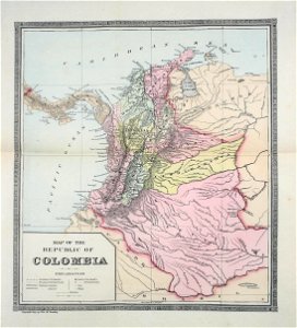
colombia
maps
1649 in maastricht
atlas beudeker
601 - 700 of 947
Next page
/ 10


![Gerardi Mercatoris and I. Hondii Atlas or Representation of the Universal World, and of the Parts of It, Made in Tables and Descriptions Very Ample, and Exact: Divided into Two Volumes [...]. [t. 1].](https://cdn.creazilla.com/illustrations/10000205839/gerardi-mercatoris-and-i-hondii-atlas-or-representation-of-the-universal-world-and-of-the-parts-of-it-made-in-tables-and-descriptions-very-ample-and-exact-divided-into-two-volumes-t-1-sm.webp)


![Paraguay, o prov. de Rio de La Plata cum regionibus adiacentibus Tucuman et Sta Cruz de la Sierra / [Blaeu], 1640s](https://cdn.creazilla.com/illustrations/10001055781/paraguay-o-prov-de-rio-de-la-plata-cum-regionibus-adiacentibus-tucuman-et-sta-cruz-de-la-sierra-blaeu-1640s-md.jpg)


![Kaarte vande Buyck-slooter… Meeren; [b] Caerte Van De Purmer; [c] Byllemer-Meer, Joan Blaeu, 1667](https://cdn.creazilla.com/illustrations/10000501445/kaarte-vande-buyck-slooter-meeren-b-caerte-van-de-purmer-c-byllemer-meer-joan-blaeu-1667-sm.jpg)